What Street Corner Cues Reveal About a Crossing
Street corner cues show how kerbs, paving and sightlines make a route appear to connect, helping you read the design without treating it as a safety assessment.
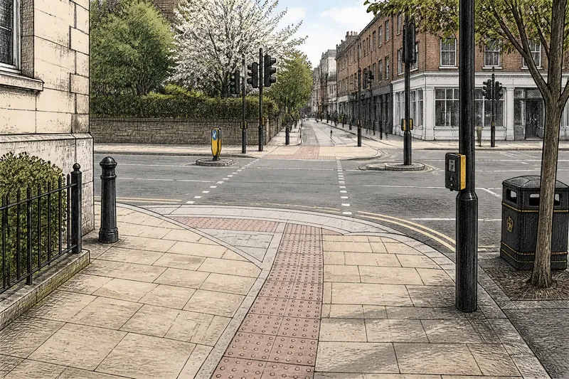
The most common mistake when reading street corner cues is to treat the nearest dropped kerb as an instruction to cross. It may simply mark where the pavement changes level. Kerbs, paving and sightlines can show how a crossing route appears to connect, but they cannot establish that it is safe or the route people are expected to use.
A corner communicates through small alignments: a kerb turns, paving continues, or an opening faces another opening. Those details reveal the design’s visual logic. The route people are expected to use, however, may be indicated by crossings, signals and other controls—and can differ from the route the paving seems to suggest.
What do street corner cues make clear?
A corner is easy to read when its shape and surfaces give a clear sense of how the pavement relates to possible crossing routes. It need not carry a sign saying “cross here”: the kerb, surface and position of the opposite landing may suggest a path.
Look at both sides of the road. A paving strip that points towards an opening in the opposite kerb suggests a connection. But the matching point may sit behind a wall, end at a narrow landing or lead to an entrance offset from the one you see. A visual suggestion is simply what the layout appears to say; it is not proof that this is the intended pedestrian route.
A clear-looking route can still be awkward for someone using a wheelchair, hard to see from a driver’s position or affected by turning vehicles. Treat “the street seems to point this way” as a description of the design, not a safety verdict.
How can a kerb suggest a crossing point?
A kerb defines the pavement’s edge, so a change in its line draws the eye. A lowered section may connect pavement and carriageway. If a similar opening appears opposite, the two points can make a route look continuous.
Notice whether the kerb seems to lead straight across or bend towards the junction. A pronounced curve may suggest a diagonal path; a straighter edge may suggest a more direct one. Neither shape confirms that the point is a formal crossing. Markings, signals and other controls can indicate an arrangement that the kerb alone does not reveal.
Check the space beside the kerb, too. A pole, bin or cycle stand may crowd the landing and interrupt an otherwise clear-looking route. That obstruction helps explain how the corner feels to use, but it does not tell you why the object is there or who is responsible for it.
Read the kerb as a clue, not as permission.
What does continuous paving suggest?
When paving slabs, bricks or a contrasting band seem to run towards a lowered kerb, the surface can make the connection between pavement and crossing point easier to see. A change in material can instead distinguish the footway from another part of the corner.
The clue may be subtle: the colour can stay the same while the lines in the paving change direction. A row of rectangular slabs may point towards an opening without any special strip. Conversely, a surface that looks continuous may stop at a drain, utility cover or repair. Not every join in the pavement carries a design message.
Compare the paving with the route across the road. If the lines seem to meet, the layout makes a connection visible. If they do not, the mismatch may reflect different construction work. Either way, the surface shows how the corner reads, not whether the paving was deliberately laid to direct pedestrians.
Why do sightlines affect how a corner reads?
A sightline is the view along the pavement, across the junction or towards the opposite landing. If that landing is visible, a route may be easier to follow with your eyes. A parked vehicle, tree, advertising board or building edge can hide it and make the layout harder to interpret.
Consider the view from more than one place. From further back on the pavement, a route may seem to line up with the opposite kerb. Closer to the edge, it may appear to point towards a turning lane or vehicle entrance. Someone arriving along the side street may see a different alignment again.
Here, sightlines are about understanding the street’s shape, not judging whether a vehicle is coming. A layout can be visually clear while crossing conditions remain uncertain.
How do route alignment and the intended crossing differ?
Route alignment is the direction in which paths appear to meet. A pavement may point towards an opening opposite, continue along the main road or angle towards a side street. These visual suggestions can compete, especially where the footway opens out around a broad corner.
Follow the paving lines, kerb edges and approach path with your eyes. If they all point towards one place, the visual route is easier to read than when they spread in several directions. A central refuge may divide a crossing into separate sections, but its presence alone does not establish where or how to cross. Look for the relevant markings, signals and local controls.
Say you approach a junction where a pale paving band leads to a lowered kerb, but the opening opposite sits slightly to the left. The paving suggests crossing at an angle; the kerb line points more directly towards the junction. The result is two competing visual routes, not an answer about which one people are expected to use. That distinction is useful: the design can suggest a path without naming the intended crossing.
What should you check when reading street corner cues?
Use these checks to describe what the corner suggests, then separate those observations from the decision about where to cross. Each item gives you a way to identify a mismatch and a next action; it does not replace crossing controls or your judgement of local conditions.
- Kerb opening: Check where the kerb changes height and whether an opening faces it across the road. If the two openings seem to connect, note that as a visual route; if they do not, look for markings or controls that clarify the arrangement.
- Paving direction: Check whether paving seams or a contrasting band point towards the opening. If they do, record that the surface suggests a route; if they stop or turn elsewhere, treat the paving as an unclear cue and look for other information.
- Opposite landing: Check whether the far-side pavement has room to receive the route you see. If it appears obstructed or offset, do not assume the visual line continues as a usable path; look for another indicated crossing point.
- View along the approach: Check whether a parked vehicle, tree or sign hides the opposite side. If it does, treat the alignment as uncertain and rely on visible controls rather than guessing where the route ends; if the landing is visible, note only that the layout is easier to read.
- Signs and markings: Check whether signs, signals or road markings point to a crossing arrangement different from the paving or kerb. If they do, follow the relevant controls; if none are apparent, do not treat that absence as proof that the suggested route is a designated crossing.
- Space beside the kerb: Check whether a pole, bin, cycle stand or uneven surface interrupts the landing. If it does, note the access problem and consider reporting the obstruction to the local authority; if the landing is clear, that still does not settle whether crossing there is suitable.
Keep notes descriptive: “the paving points towards the side street” says more than “this is the safe crossing”. For a decision about crossing, consider the controls and conditions present and what is appropriate to your circumstances. A local authority can explain how to report a confusing layout or obstruction.
What questions do readers ask about street corner cues?
Does a dropped kerb mean the crossing is intended?
No. A dropped kerb shows a change in level that may connect pavement and carriageway, but it does not establish that the point is a formal or suitable crossing. Check the wider layout and any markings, signs or signals.
Can paving patterns identify a designated crossing?
Not by themselves. Paving can make a route look continuous, but its pattern may also reflect repairs or construction choices. It cannot replace the information provided by crossing controls.
Why might opposite corners not line up?
Junction shape, driveways, drainage, street furniture and separate construction work can all affect where paving and kerbs meet. The mismatch may make a route look bent or broken, even if each pavement edge appears clear from where you stand.
Does a more obvious crossing mean a safer one?
No. Obviousness describes how readily the layout suggests a route; it does not assess crossing conditions. Do not use paving or kerb alignment as a substitute for observing traffic and following the relevant controls.
What can street corner cues tell you—and what can’t they?
Street corner cues can show whether kerbs, paving and sightlines appear to lead towards the same place. When they disagree, the conflict helps explain why the corner is difficult to read. It still does not tell you which route people are expected to use or whether crossing there is safe.
At a junction, compare the route suggested by the near-side paving with the far-side landing, then check whether signs, markings or signals indicate a different arrangement. The useful point about street corner cues is precisely where their message stops: they help you read the layout, but they do not make the crossing decision for you.